SMA26 GNSS IMU RTK GPS Surveying Equipment Rover Base Handheld Collector with Survey Software, NOAA Certificated, 1408 Channels, 1cm Accuracy, Kilometer Wireless Distance(exclude tripod&pole)
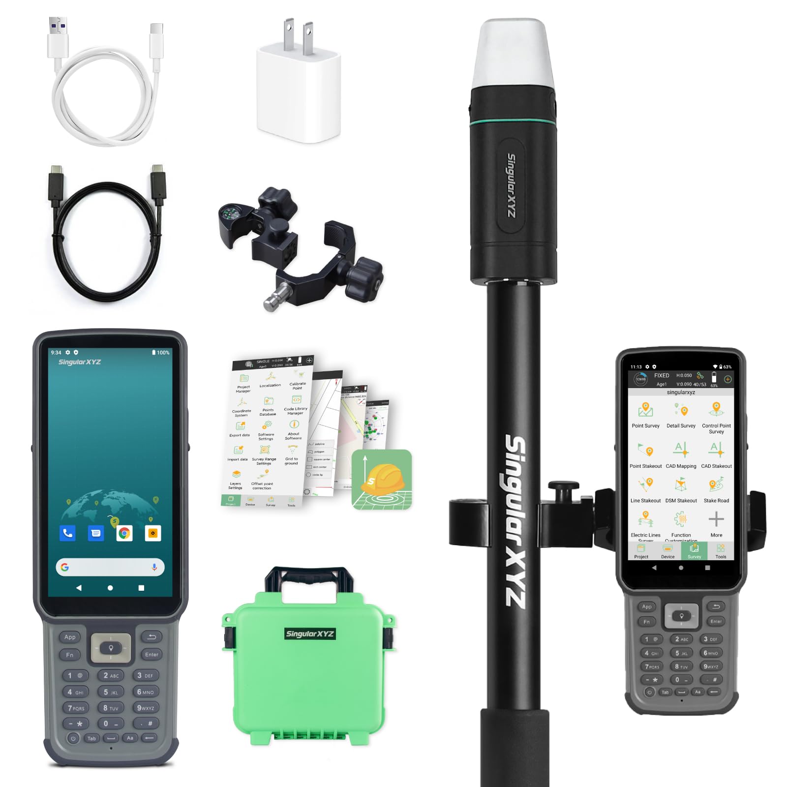
E1 RTK GNSS Survey Equipment 20 Hours Endurance RTK GNSS GPS with IMU Rover & Base Handheld Collector with Survey Software RTK Surveying Equipment,1408 Channels, 5km UHF Range,60° Tilt Survey
Laser Distance Meter,RockSeed IP54 Laser Measure with 2 Bubble Levels,Portable Laser Rangefinder Digital Distance Meter with 4 Line LCD Display and Bigger Clear Backlight
Contractor Hand Held Sight Level (Durable)
Bosch Professional Optical Level GOL 32 D, ideal for outdoor use, 32x magnification, up to 120m range | Model: 0601068500 with 1 year warranty
BOSCH GOL 32CK 32X Automatic Optical Level Kit, Includes Aluminum Tripod, Grade Rod, Plumb Bob, Tool Kit, & Carrying Case
Handheld GPS Survey Equipment, BEVA GPS Land Measuring Instrument, Mini Handheld GPS Units for Mountainous Land, Slope and Flat Field
Draper 100m Surveyors Tape Measure Fibreglass | Measuring Tape with Soft Grip Winding Grab Handle | 51091
Land Surveying Equipment, 4 Section Survey Pole 2 Meter 4 Section Survey Pole RTK GPS Carbon Fibre Surveying Prism Pole with Level Bubble 0mm Constant
CST/berger 19-200SC MagnaTrak 200 Series Magnetic Locator with Soft Case
2M Length Survey Pole, Detachable 4 Section RTK GPS Prisms Pole, Carbon Fiber Surveying Pole with Level Bubble 0mm Constant, Storage Bag
Handheld GPS Survey Equipment, GPS Land Area Meter Land Survey Measuring Instrument , Land Measuring Tool for Forest Farmland Mountain Mining Lake
Exacompta - Ref 2026Z - Chartwell Casebound Field Survey Book - 130 x 205mm in Size, Excellent Strength When Wet, Ideal for Use Outside, Plain With 2 Lines, Yellow
Top Quality by BEXCO Brand Heavy Duty Mechanical Planimeter Level and Survey Equipment Civil Instrument
Themisto TH-M81 Laser Distance Meter (50m Range) with Backlit LCD and Pythagorean Mode
Land Surveying Equipment, Handheld GPS Land Meter, Professional GNSS Receiver Surveryor Tool with Color Screen for Slope Distance/Area Measurement
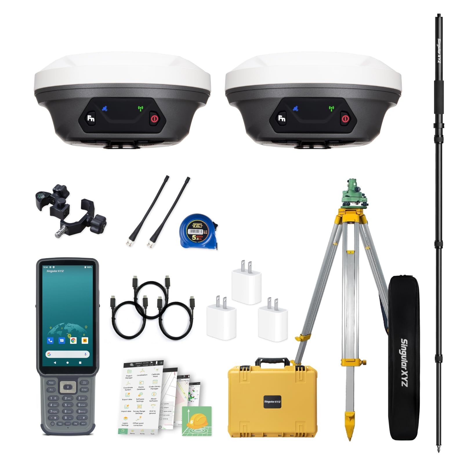
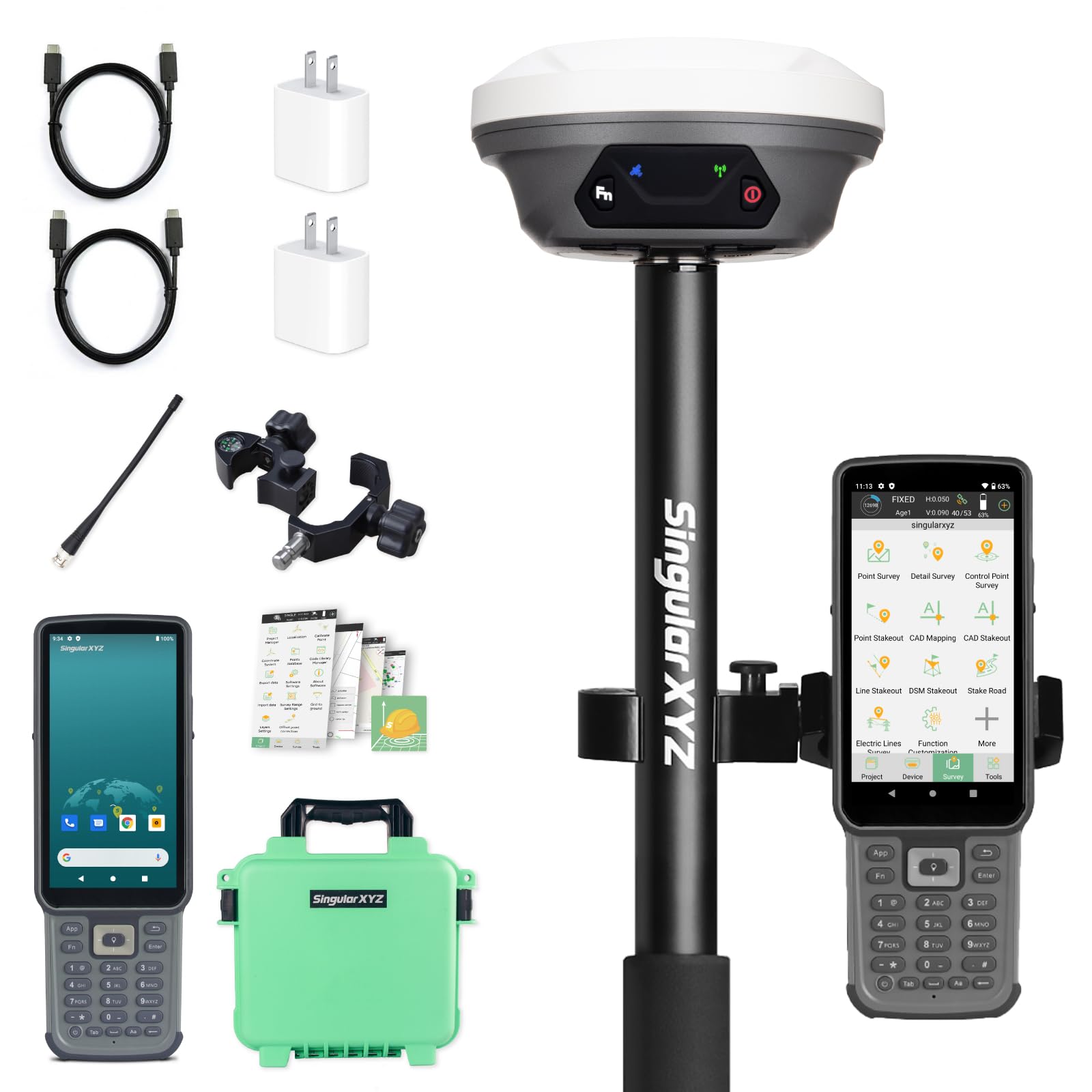
SingularXYZ RTK GNSS Survey Equipment with Rover Handheld GPS for Surveying, Handheld Controller and Survey Software, for Construction and Geodetic or Land Survey Layout Planning
SingularXYZ E1 RTK GNSS Survey Equipment GPS Receiver with IMU Rover & Base Handheld Collector Land Total Station Surveying Equipment, Navigation System Survey Software(include Pole, Tribrach, Tripod)
KEZERS 32X Automatic Optical Level Kit with Self- Leveling Magnetic Dampened Compensator and Transport Lock,High Precision Height/Distance/Angle Level Measure - KL-32X
BEVA Handheld GPS Survey Equipment, GPS Land Measuring Instrument, Mini Handheld GPS Units for Mountainous Land, Slope and Flat Field
Oniissy Surveying Carbon Fiber Pole 2M 4-Section GPS GNSS RTK Rod 32mm Diameter Lightweight Portable Survey Equipment Compatible All GPS Interfaces(2M)
VEVORAutomatic Transit Level 26X Optical Survey Equipment Auto Level Kit High Precision Angle Level Measure Builders Level with Magnetic Dampened Compensator and Transport Lock, IP54 Waterproof
Yaeccc Automatic Level 32X Optical Transit Survey Auto Level High Precision Level Gauge Measure Meter Machine
DEWALT Transit Level, Surveying Tool with Tripod and Rod, 20X Magnification (DW090PK)
Automatic Level 32X Optical Transit Survey Auto Level High Precision Level Gauge Measure Meter Machine
Surveying Equipment, NOAA Certificated SMA26 GNSS IMU RTK GPS Rover Base Handheld Collector with Survey Software, 1408 Channels and 1cm Accuracy(Exclude Tripod&Pole)
SMA26 GNSS IMU RTK GPS Surveying Equipment Rover Base Handheld Collector and Survey Software, NOAA certificated, 1408 Channels, 1cm Accuracy(Exclude Tripod&Pole)
TENABLE NAUTICAL MART Wooden Cross Staff with Pole for Survey,Staff with pole having strong iron Survey Equipments (Pack of 1)
Iglobalbuy Automatic Self-Leveling Rotary Laser Rotating Horizontal & Vertical Laser Level Kit 500M w/Remote Control + Receiver, Leveling Transit Laser Level Red Beam for Construction (Rotary Laser)
Elan Publishing Company E64-8x4W Wire-O Field Surveying Book 4 ⅞ x 7 ¼ Yellow Stiff Cover (E64-8x4W Yel)
iSiLER Laser Distance Meter, 50M Range Digital Measuring Tape with Backlit Display & Data Record, Multiple Measurement Modes, Measure Distance, Area and Volume, IP54 Waterproof
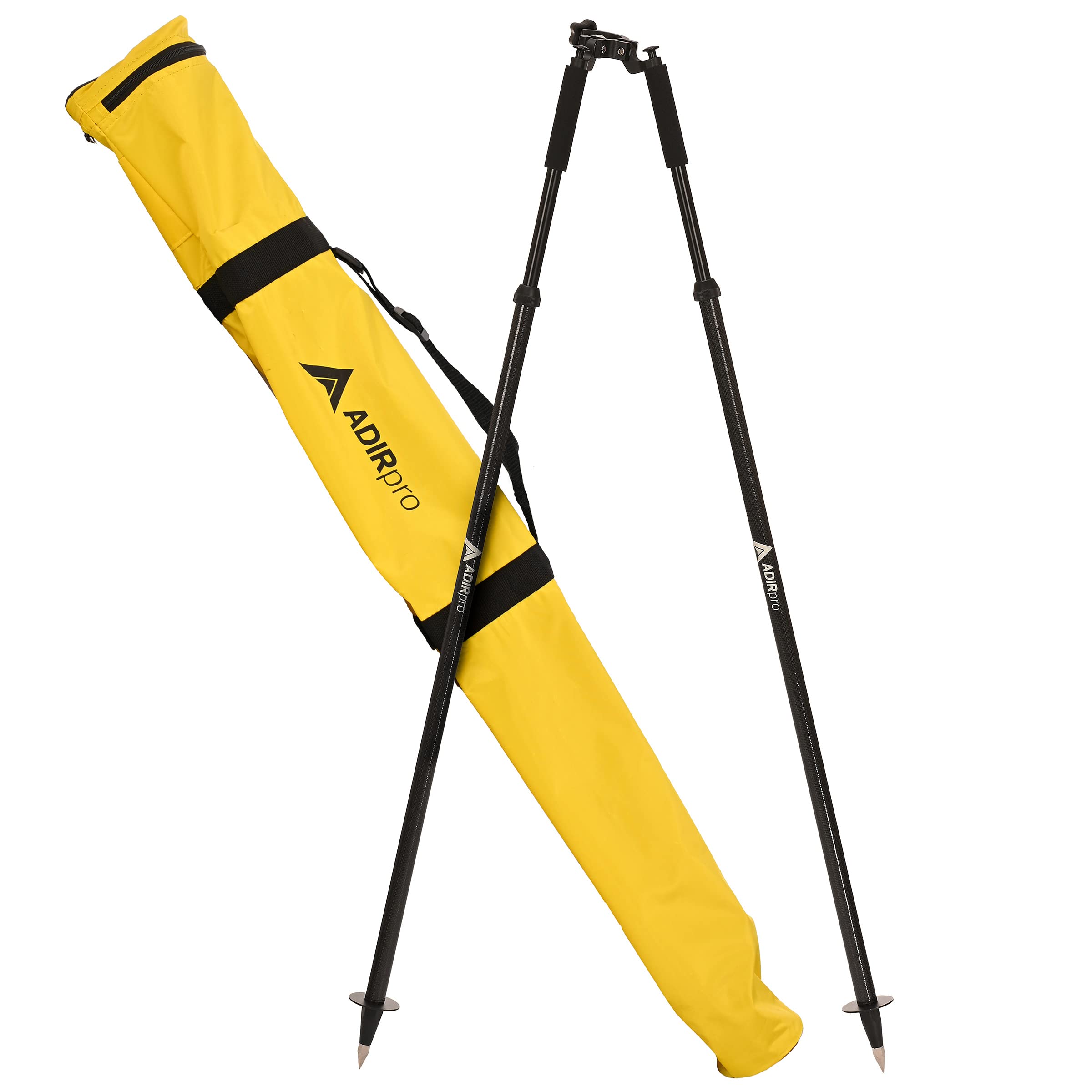
AdirPro Prism Pole Tripod – Aluminum Range Pole Tripod – Use for Survey Pole, Rover Rod, GPS Pole – GNSS RTK Rod Stand - Survey Equipment for Total Station Surveying (Fluorescent Green)
Topcon 24x Automatic Level AT-B4 60909
Survey Measuring Chain With 100 Link & 10 Arrow Free Ground Measuring Chain/Land Survey Chain 20 Metre With Brass Tags And Brass Handle With Best Quality Long Time Use Survey Equipment
QWORK Adjustable Grade Rod Level, Portable Measuring Instrument, Special Horizontal Bubble for Tower Ruler, Right Angle 90 Degree Level
Klein Tools 935DAG Digital Electronic Level and Angle Gauge, Measures 0 - 90 and 0 - 180 Degree Ranges, Measures and Sets Angles
Carbon Fiber GPS Rover Rod Telescopic GPS Rover Rod for Land Surveying & Engineering – RTK GPS/GNSS Accessory for Surveying and Measuring Poles
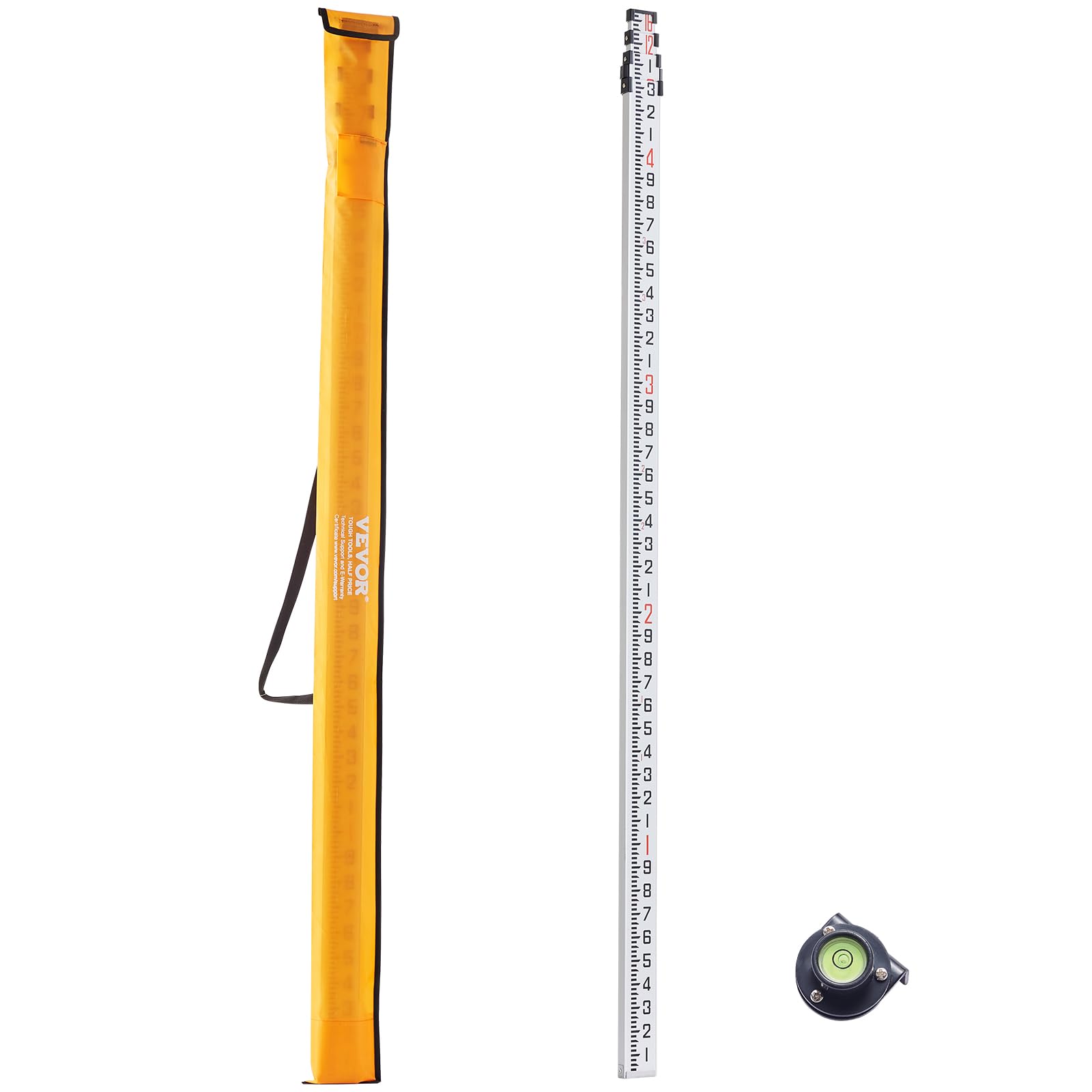
Firecore 16-Foot Aluminum Grade Rod - 10ths, 5 Sections Telescopic with Bubble Level-FLR500B
zozenMeasuring Wheel in Feet and Inches, Collapsible with One key to Zero, Kickstand, Starting Point Arrow and Cloth Carrying Bag, Measurement 0-9,999 Ft Measure Wheel.
Grade Rod,16-Foot Aluminum Grade Rod - 10ths,Grade Stick for Laser Level,Survey Rod,Grade Rods,Survey Pole,With Bubble Level, 5-Stage Telescopic,Double-Sided Scale Telescopic Leveling Rod
Patwari Survey Kit Pack of 5 Items By Tenable Nautical Mart
RTK GNSS Survey Equipment with Network RTK Rover, Handheld Controller and Survey Software, Featuring a 60° Tilt and Built-in IMU, for Construction and Geodetic or Land Survey Layout Planning
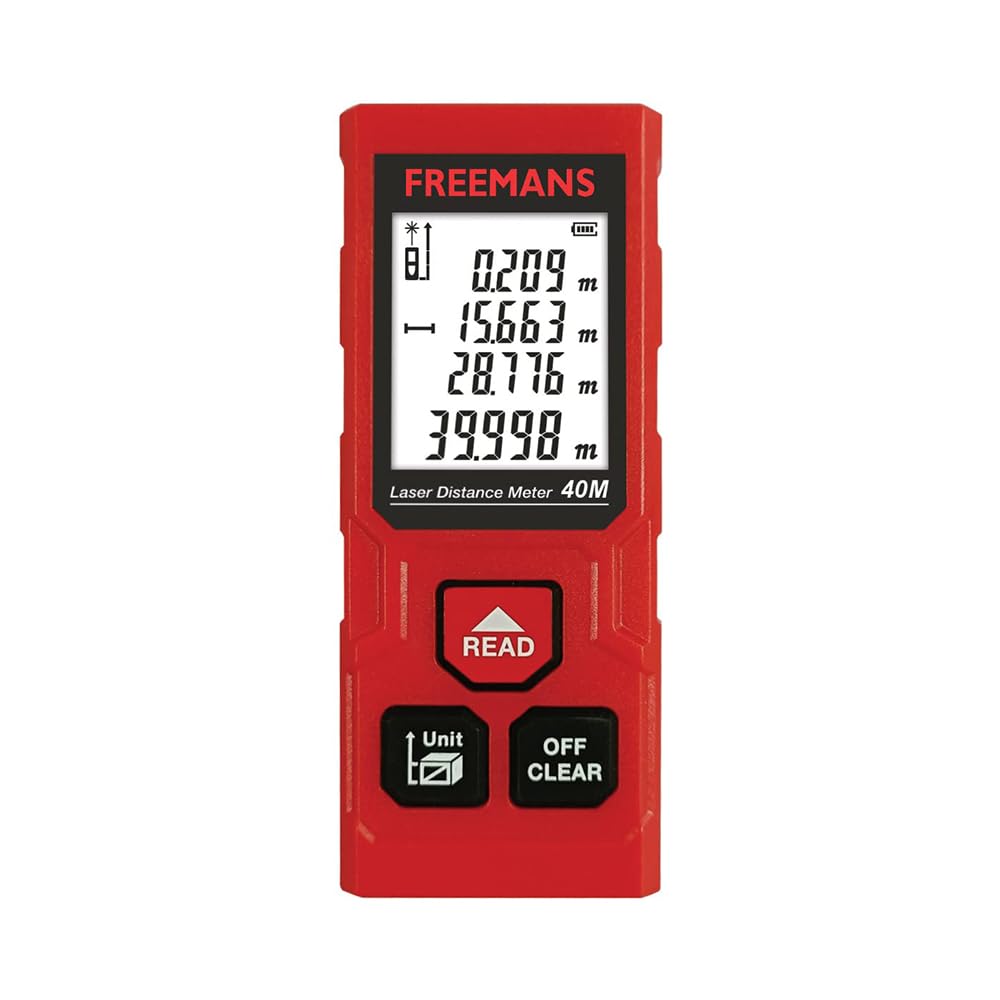
FREEMANS PROECO-L40 40m Laser Distance Meter with Area, Volume, Pythagorean Measurement and Self-Calibration Function, Carry Bag and Batteries Included, Best Suitable for Indoor Measurements
E1 RTK GNSS Survey Equipment GPS Receiver with IMU Rover & Base Handheld Collector Land Total Station Surveying Equipment, Navigation System Survey Software(include Pole, Tribrach, Tripod)
ZL180 Handheld GPS Survey Equipment, Land Surveying Equipment, Handheld GPS Land Meter, Land Measuring Instrument Surveryor Tool for Flat Fields,Forest,Farmland and Mountain
Karomouj Karo-988S Anti Cut Resistant Level 5 Protection With Elastic Hand Fitting Safety Gloves (Free Size, Grey, 1 Pair), Pack Of 1 - Rubber
JCB HAND TOOLS Measuring Wheel - 12" wheel counts upto 10,000 feet. Complete with Built in stand, 22025855
AdirPro Universal Survey Tripod – Laser Level Tripod – Transit Level Tripod - Quick Clamp - Heavy Duty Contractor Tripod 5/8” x 11” Thread (Green Aluminum)
R26 V1 Rover GNSS Surveying Rover with LP80 Collector RTK Receiver NOAA certificated,Static Survey,RTK Survey for Topographic,Land Survey,Correction by CORS,Mobile Base,TCPIP(Exclude Pole)
DEWALTRotary Laser Level Kit, Indoor/Outdoor Survey Laser Transit (DW074KD)
Komelon 6633 Open Reel Fiberglass Tape Measure, 300-Feet, Yellow
Elan Publishing Company - E64-8x4S Org E64-8x4S SewnField Surveying Book 4 5/8 x 7 1/4 Orange Stiff Cover
Portable GPS Land Area Meter 100-240V High Precision Handheld Land Area Meter Land Survey Measuring Instrument with US Plug handheld gps units land surveying equipment
AdirPro Prism Pole Tripod – Aluminum Range Pole Tripod – Use for Survey Pole, Rover Rod, GPS Pole – GNSS RTK Rod Stand - Survey Equipment for Total Station Surveying (Fluorescent Green)
E1 GNSS GPS RTK Base Station Land Surveying Equipment Total Station GNSS Receiver High Accuracy Static Surveying, Coodinates Collection, Point Surveying
SitePro 21-236 36" (92cm) Heavy Duty Lath Bag, Hi-Vis Orange
VEVOR Aluminum Grade Rod, 16-Feet/10ths 4 Sections Telescopic Measuring Rod,Double-Sided Scale 1/10ft Leveling Rod Stick,Aluminum Alloy Survey Rod w/Bubble Level &Carrying Bag for Houses,Walls,Floors
VEVOR Red Rotary Laser Level 1650ft,360 Degree Self Leveling Laser Level Kit,with Surveying Tripod&5m Staff,IP66 Waterproof Remote Control,5 Rotation Speeds&4 Angles Adjustment(Ship in Three Packages)
VEVOR Automatic Optical Level 26X Optical Auto Level Kit High Precision Height/Distance/Angle Level Measure Builders Level with Magnetic Dampened Compensator and Transport Lock, IP54 Waterproof
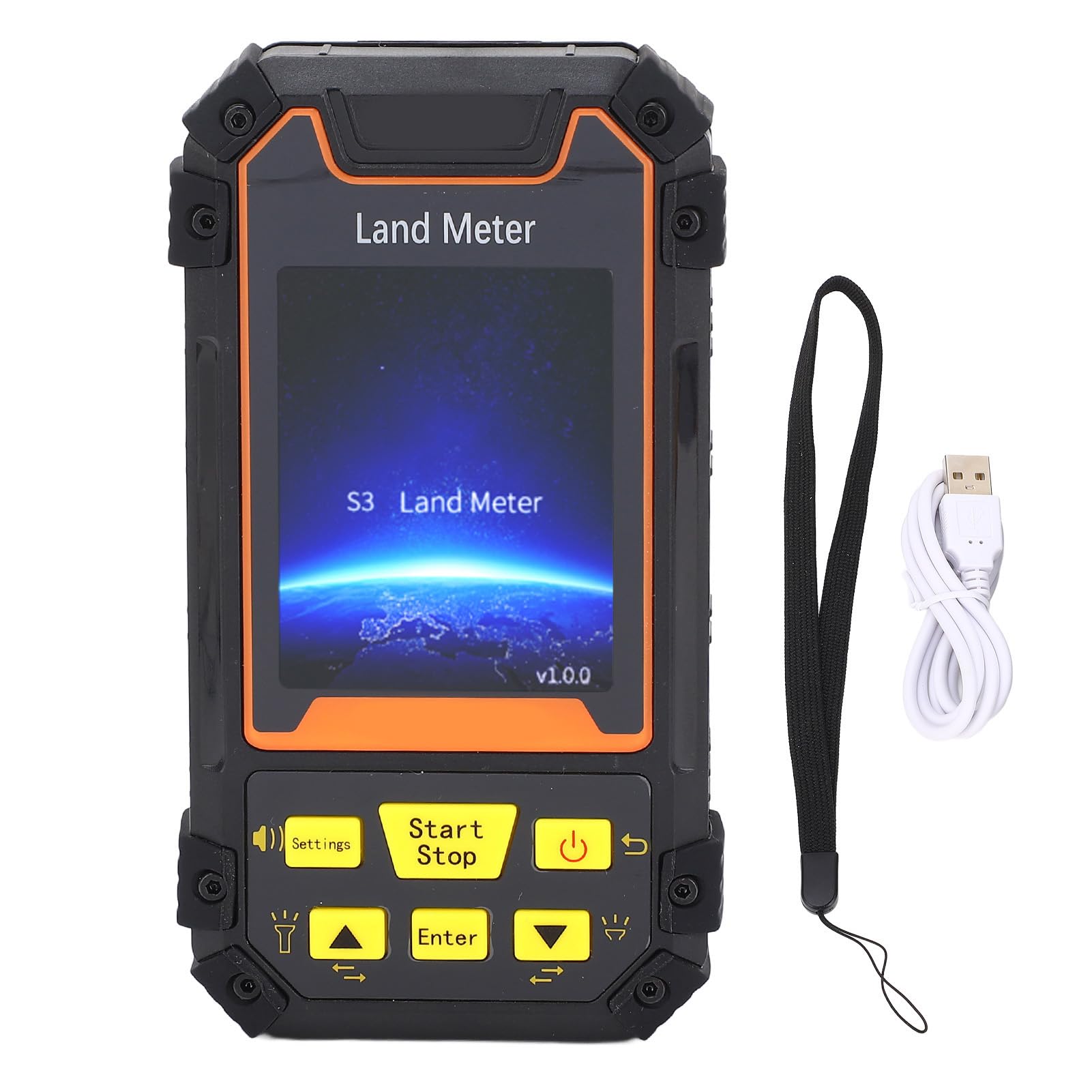
ZPLuz GPS Land Meter, GPS Survey Equipment with 2.4'' LCD Screen, Built-in Barometer, Accurate Measurement, Rechargeable High Accuracy Real-time Navigation, for Forest Farmland Mountain Mining Lake
Johnson Level & Tool 40-6517 Self-Leveling Rotary Laser System, 29 x 7", Red, 1 Kit
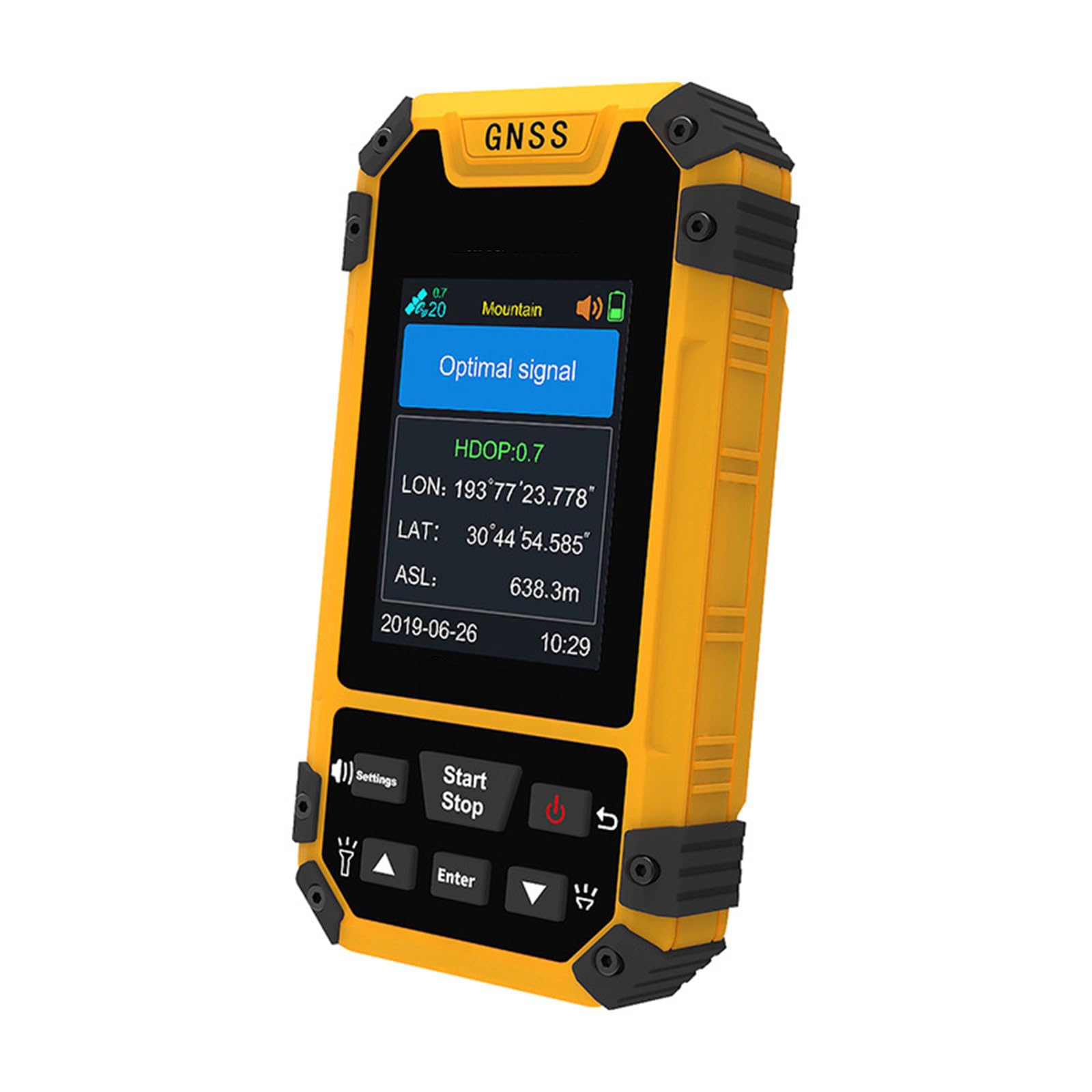
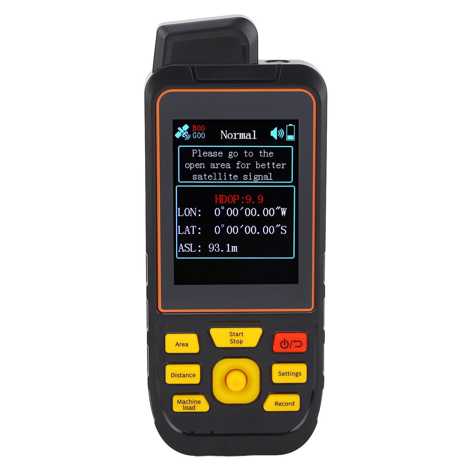
GPS Latitude and Longitude Locator,Handheld GPSSurveyEquipment,AltitudeSurvey/PositionNavigation/Travel/Record/Project Lofting,for Land Survey,Outdoor Travel,Site Survey
Telescopic Leg Tripod Instrument, Heavy Duty Aluminum Surveying Tripod for Surveying Construction with 5/8 Inch 11 Thread Flat Head for Total Station, Theodolite, Automatic Level-Tk1015
ZPLuz Handheld GPS Survey Equipment,Coordinate Measurement and Route Edit,Rechargeable High Accuracy Real-time Navigation,Altitude Meas,for Forest Farmland Mountain Mining Lake
Satellite Finder - Surveyors Compass - Surveyor Compass - Clinometer Forestry - Survey Compass - Inclinometer Compass - Compass Inclinometer - Compass Clinometer Offroad - Survey Tools - STEREN
Land Surveying Equipment, 4 Section Survey Pole 2 Meter 4 Section Survey Pole RTK GPS Carbon Fibre Surveying Prism Pole with Level Bubble 0mm Constant
NAVA F30 Handheld GPS Units,Colorful Map Handheld GPS Navigation Device,Land Accuracy Surveying GPS Equipment for Outdoor Hiking Hunting Traveling Adventures
DEWALT Transit Level with Tripod, Rod, and Carrying Case, 20X Magnification (DW092PK)
SMAJAYU R26 V1 Rover GNSS Surveying Rover with LP80 Collector RTK Receiver NOAA certificated,Static Survey,RTK Survey for Topographic,Land Survey,Correction by CORS,Mobile Base,TCPIP(Exclude Pole)
Calculated Industries #6575 DigiRoller Plus III 12.5 Inch Estimators Electronic Distance Measuring Wheel with Large Backlit Digital Display; Measure in Feet, Inches, Meters, Yards; FREE Carrying Pack
Automatic Self Leveling Rotary Laser, 500m Red Laser Survey Level with Tripod Aluminum Grade Rod, 360 Degree Rotating Horizontal & Vertical Laser Level Kit, Transit Level for Construction
Reflective Target Canada Tape Survey (100pcs 40X40mm, White)
GPS Land Measuring Instrument, Handheld GPS Survey Equipment,CoordinateMeasurementandRouteEdit,Rechargeable High Accuracy Real-time Navigation, Altitude Meas
YHUEGH GPS Land Meter LCD Display Land Survey Equipment, GPS Land Mapping Machine Distance Area Measurement Tool, for Forest Farmland Mountain Mining Lake
7 pcs Hanging Bubble Line Level for Building Trades, Engineering, Surveying, Metalworking and Other Equipment Measure
AdirPro Surveying Extension Pole with Height Lever | 1.25 Inch Outside Diameter Extension Rod Increases Height of Land Survey & Construction Equipment | Pole Extension Measures 8.5 Inches Long
TelPal Landline Test Phone Line Set Telecom Check Telephone Line Dedicated Check Line Survey Line Machine Tester to Alligator Clip Set Equipment
Saysurey Aluminum Survey Tripod Heavy Duty Construction Tripod Stand Laser Level Tripod with 5/8"-11 Thread Flat Head Quick Clamp Transit Tripod for Automatic Optical Level, Built in Strap
D 51091 Fibreglass Surveyors Tape, 100m/330'
E1 RTK GNSS Survey Equipment 20 Hours Endurance RTK GNSS GPS with IMU Rover & Base Handheld Collector with Survey Software RTK Surveying Equipment,1408 Channels, 5km UHF Range,60° Tilt Survey
Sikeewii 7PCS Mini Bubble Level Hanging Line Spirit Level for Bricklaying Plumbing Guttering Tiling Building Trades Engineering Surveying Equipment Adjusting Angle Balance Measuring Tool
Firecore Aluminum Quick Clamp Tripod, Construction and Surveying Equipment - Adjustable Sturdy Lightweight Support Base - FT160B
XELDEC Fully automatic operation PQWT-M100 Water well drilling machine Water finder detector 100M survey equipment
Eujgoov GPS Land Survey Equipment Accurate Global Coverage for Farmland Mountain
GPS Land Meter, Handheld GPS Survey Equipment With 2.8'' LCD Color Screen, Rechargeable Professional Area Measurement Mountain Slope Distance Meter for Forest Farmland Mountain
2 pcs Hanging Bubble Line Level for Building Trades, Engineering, Surveying, Metalworking and Other Equipment Measure (Yellow) (Aluminium)
Handheld GPS Survey Equipment, Coordinate Measurement and Route Edit, Rechargeable High Accuracy Real-time Navigation, Altitude Meas, for Forest Farmland Mountain Mining Lake
Mountlaser Surveying Tripod, Aluminum Survey Tripod with 5/8-Inch 11-Threaded Flat Head Quick Clamp for Total Station Theodolite
Vorole Land Surveying Machine, Professional GNSS Receiver GPS Land Meter with Color Screen for Area Measurement
E1 GNSS IMU RTK GPS Surveying Equipment Rover Receiver Rtk Gnss Handheld Collector and Survey Software, 1408 Channels, 1cm Accuracy, 5km Distance
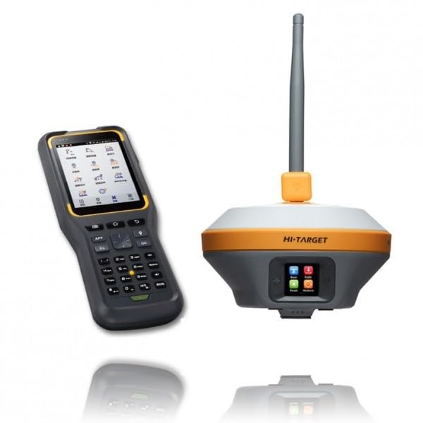
Hi-Target IRTK5 High-Precision GNSS RTK Survey Equipment with Rover, Base Station, and Handheld Collector Software
E1 RTK GNSS Survey Equipment RTK GNSS GPS with IMU Rover & Base Handheld Collector Total Station Surveying Equipment, with Survey Software 1cm Accuracy, 1408 Channels(Exclude Poles,Tripods,Tribrach)
Allmeter Magnetic Digital inclinometer, Digital Angle Finder 0-360(4 * 90) va LCD Backlight Display with v-Groove Magnetic Base Digital Level Spirit Angle Gauge Bevel Box for Carpentry,Building,Home
AdirPro Prism Pole Bipod – Carbon Fiber - Range Pole Bipod - Monopod for Rover Rod, GPS Bipod, Leveling Staff – GNSS Rod Stand - Survey Equipment for Total Station Surveying
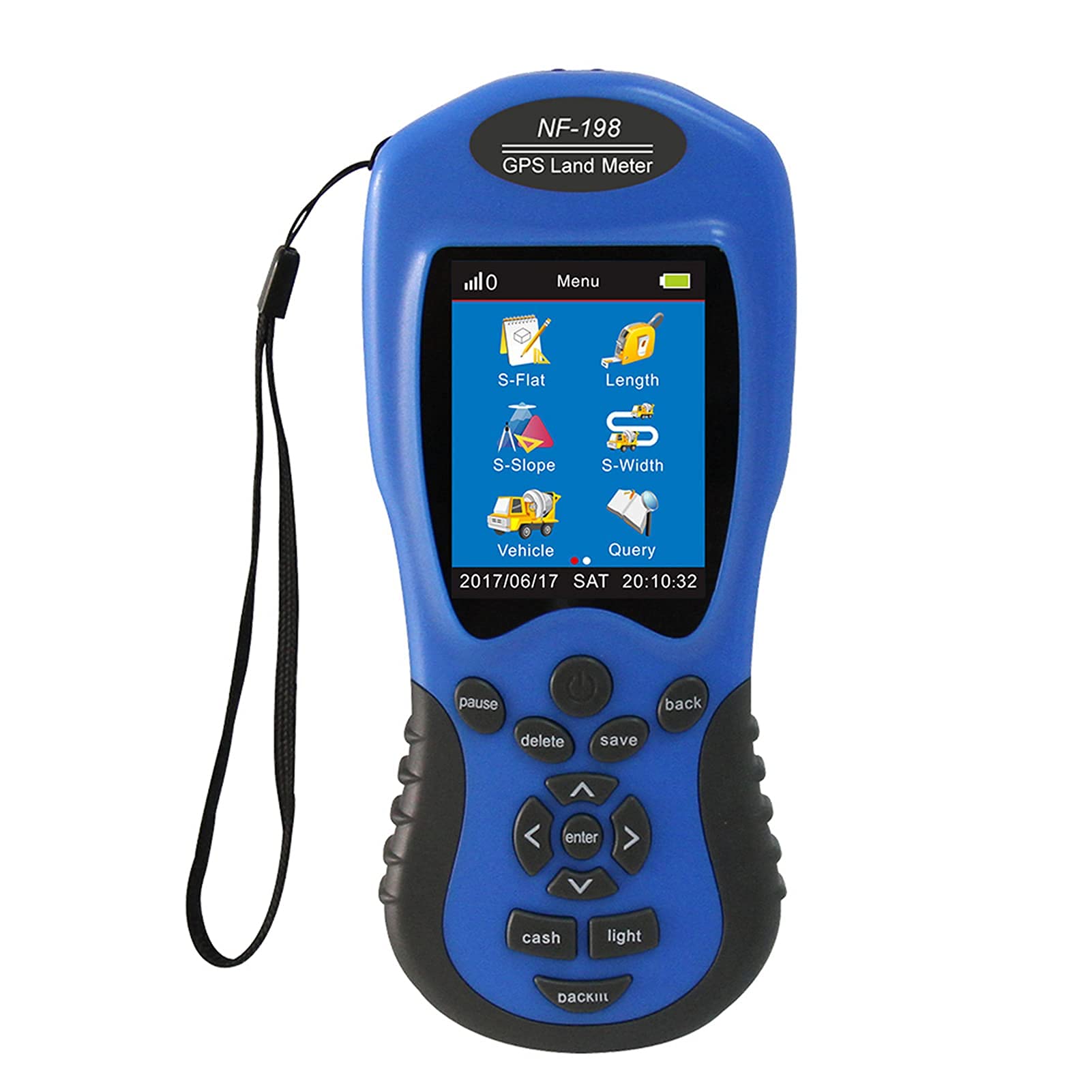
Survey Equipment, NF-198 Survey Equipment Use Farm Land Surveying Mapping Area Length Outdoor Measuring
SMAJAYU Surveying Equipment, NOAA Certificated R26 V2 GNSS IMU RTK GPS Rover Base Handheld Collector with Survey Software, 1408 Channels and 1cm Accuracy(Exclude Tripod&Pole)